MIAMI NEIGHBORHOOD GUIDE
Venetian Islands Homes for Sale: An Island-by-Island Buyer's Guide
Waterfront and interior estates across the residential islands of the Venetian Causeway.
By Anthony Guerriero, Manhattan Miami Real Estate | Updated August 2026
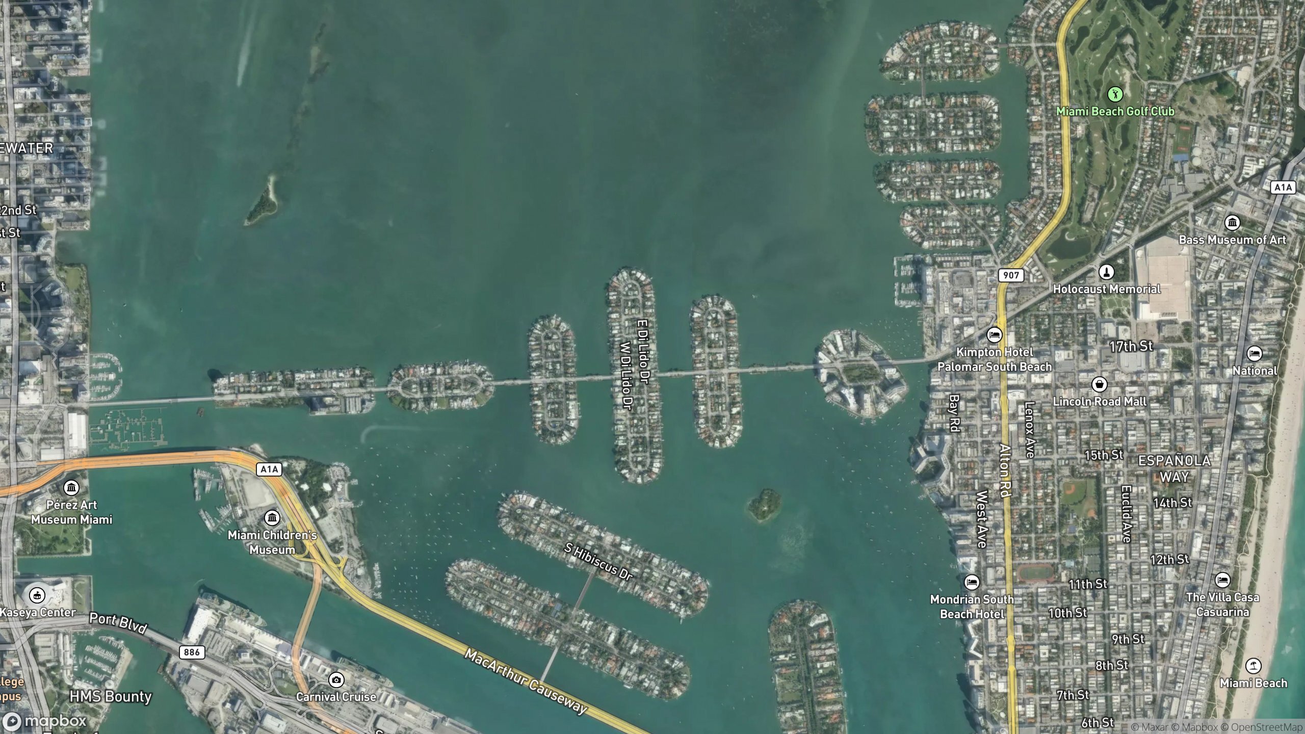
The Venetian Islands are a chain of six islands in Biscayne Bay linked by the Venetian Causeway between downtown Miami and Miami Beach. Biscayne Island and San Marco Island sit in the City of Miami. San Marino, Di Lido, Rivo Alto and Belle Isle sit in the City of Miami Beach. Each island docks and prices differently.
Venetian Islands Real Estate Map
The map follows the neighborhood's mapped land or street edge and labels the principal building benchmarks directly. Adjacent neighborhoods remain separate.
CURRENT INVENTORY
Venetian Islands properties for sale
The listing view is limited to this neighborhood and for-sale inventory. It does not expose a broad site search.
Public inventory is reviewed building by building so the page does not broaden your search beyond Venetian Islands. Request the current building-specific list, including relevant private and coming-soon opportunities where available.
Request current Venetian Islands inventoryAvailability changes frequently. Listing status, boundaries, building rules and property details must be independently confirmed.
Venetian Islands at a glance
Most buyers arrive here having seen a single listing and assuming "Venetian Islands" describes one product. It does not. Two homes with identical square footage, one on the north side of Rivo Alto and one on the south side of San Marco, can be separated by a wide gap in price, in water depth at the seawall, and in what you look at from the pool deck. Municipal jurisdiction changes mid-causeway. Building departments, permitting timelines, code enforcement and property tax millage all follow that line.
The count is worth pinning down, because sources disagree and buyers get confused. The National Register of Historic Places nomination for the Venetian Causeway states that the causeway "cuts across six islands of which the four central islands were created from material dredged from the bay bottom for a residential development shortly before the construction of the causeway." So the residential chain is six islands, and the dredge-fill origin applies squarely to the four in the middle. That origin explains most of what a buyer needs to know: the lots are platted in tight, regular rows, the streets are short, almost every parcel touches water, and the finished grade of the land was set nearly a century ago. Grade matters enormously for the flood and elevation questions covered further down.
The same nomination fixes the order and the vintage. It lists the islands "from west to east" as Biscayne Island, San Marco, San Marino, Di Lido, Rivo Alto and Belle Isle. San Marino sits before Di Lido travelling east, a sequence often reversed elsewhere, so check the order against the plat rather than against a neighborhood page. The nomination records that the Bay Biscayne Improvement Company built the four central islands and the causeway between 1921 and 1926, platting Rivo Alto in February 1922, Di Lido in January 1923, and San Marino and San Marco in June 1923. Belle Isle was already there. F.C.B. Le Gro, one of the company's principals, had dredged it in 1916, and the four new islands were built "one at a time, beginning west of the existing island of Belle Isle." Biscayne Island is the late arrival: the nomination states it "was not part of the original Venetian Islands development although it was partially dredged to sustain the bridges," and that it was platted in December 1936 by a separate company. Plat date sets the earliest possible vintage of the housing stock on an island, which is why Biscayne Island and the four central islands do not read the same way on a walk.
The single-family islands are small and residential. Belle Isle, the easternmost, is the outlier. It developed as a condominium island rather than a house island.
Flagler Monument Island is not a residential market at all. The City of Miami Beach places it "on Biscayne Bay between the MacArthur and Venetian Causeways" and describes it as an artificial island west of South Beach, which is the simplest way to orient the chain against the guard-gated islands on the MacArthur. It is a City of Miami Beach public park, listed by the city as Monument Park, open sunrise to sunset with access by boat only and no boat service provided by the city. At its center stands a 97-foot obelisk built in 1921 by Miami Beach founder Carl Fisher, ringed by four 18-foot statues. You can visit it. You cannot buy on it.
For a wider view of where this chain sits among Miami's ultra-prime waterfront enclaves, see our guide to billionaire neighborhoods in Miami.
Island by Island
| Island | Buyer fit and diligence |
|---|---|
| Biscayne Island | The westernmost island and the first one you reach from the Miami mainland. |
| San Marco Island | The second island from the Miami side, also City of Miami. |
| San Marino Island | The first island on the Miami Beach side, mapped RS-3 and RS-4 on the City of Miami Beach zoning map. |
| Di Lido Island | One of the larger Miami Beach-side residential islands, and in practice the one most buyers see first because it carries a wide mix of product. |
| Rivo Alto Island | The easternmost of the single-family islands, closest to Miami Beach proper, and likewise RS-3 and RS-4 on the city zoning map. |
| Belle Isle | Belle Isle is the exception in the chain. |
BUYER GUIDE
The Causeway: History, Access, and the Toll
The chain exists because of a bridge. According to the Miami-Dade County Public Works fact sheet for the causeway, the current alignment follows the original route of the Collins Bridge, a wooden structure built in 1913 that replaced ferry service to the young Miami Beach. The National Register nomination gives the two ends precisely: the causeway "connects to N. E. 15th Street, Miami, at the west axis and Dade Boulevard, Miami Beach at the east axis." That is the practical geography of the drive. You enter the chain off NE 15th Street on the Miami side and leave it onto Dade Boulevard on the Miami Beach side.
On the completion date of the causeway itself, the two authoritative records differ slightly, and it is worth saying so rather than picking one. The National Register nomination describes the causeway as "completed in 1926," approximately two and one half miles long, composed of twelve bridges including two drawbridges, with a period of significance running 1926 to 1930. It credits Harvey Stanley as engineer and the Raymond Concrete Pile Company of New York as builder. Miami-Dade County dates construction to 1927. Either way the structure is a mid-1920s object, and its low profile, arch beams and geometric guardrails are the reason it survived rather than being replaced outright.
Miami-Dade County confirms the causeway carries 12 bridges, 10 fixed spans and 2 bascule leaf spans, and that it was included on the National Register of Historic Places in 1989. Both the City of Miami and the City of Miami Beach have separately designated it a local historic landmark. That layered protection is why residents were able to defeat an earlier state proposal to replace the bridges outright: the county records that the replacement plan "was opposed by the area's residents as FDOT's proposal was not consistent with the historic nature of the existing bridges."
The nomination also describes how the middle of the chain is stitched together. The spans between San Marco and San Marino, between San Marino and Di Lido, and between Di Lido and Rivo Alto are each achieved by two short bridges resting on "a central landing, a small narrow piece of landfill landscaped with sea grape and palm trees." Those landings are not residential islands, and they are one reason published counts of Venetian Islands run higher than six. The county's own causeway fact sheet, for instance, refers to 11 man-made Venetian Islands. Six is the number that carries residential plats, and six is the number you can transact on.
Restoration has come in waves. The county documents a major rehabilitation of the causeway bridges' beams and decks between 2009 and 2011, with construction costs "slightly more than $7.1 million," funded from causeway toll revenues and federal grant dollars through the County Incentive Grant Program.
A far larger program is now live. Miami-Dade County announced a $100.5 million award from the U.S. Department of Transportation Bridge Investment Program for the Venetian Causeway Replacement and Resilience Project. It covers 11 bridges, including the easternmost movable bridge. The county states the new bridges will be 16 feet wider than the current structures, with increased vertical clearances to address sea-level rise and a design life of approximately 75 years against the original 50. FDOT's project record shows Location and Design Concept Acceptance on December 15, 2022, proposes short-span reinforced concrete arch beam bridges with railings replicating the existing ones, and specifies two 12-foot travel lanes with 4-foot bike lanes and 4-foot sidewalks on each side. The county held a public meeting on March 18, 2026, and expects to finalize design by the summer of 2026 with construction advertisement to follow, subject to permit coordination. The county also states that "at no point will traffic be completely impeded," with temporary structures and open lanes maintaining flow.
Treat that program as live rather than settled. Construction staging affects access, noise and resale timing, and it is a fair question to raise with a listing agent on any island.
One further constraint on these bridges is load, and it matters more here than on almost any other Miami waterfront address. The county's own Venetian Causeway fact sheet records that on April 10, 2014 new signage lowered the weight limit from 15 tons to 11 tons on all of the Venetian bridges except the West Venetian Bascule Bridge, which was posted at 5 tons, with the limits enforced by FDOT. The West bascule segment has since been replaced and postings change, so confirm the current limit with the county before you plan anything heavy. On a chain where much of the value is created by rebuilding, what a truck is allowed to carry across the causeway is a scheduling and cost input, not a footnote.
A toll plaza operates on Biscayne Island at the Miami end. Miami-Dade County publishes a two-axle SunPass rate of $3.25 per crossing and a Toll-by-Plate rate of $6.50, effective October 1, 2025, with a $2.50 monthly invoice fee on Toll-by-Plate. The county also runs two annual plans. The Property Owner Plan carries no cost for owners of Venetian property who can show a property tax bill and hold an active SunPass, and is limited to two-axle vehicles. The Commuter Plan costs $120 and runs October 1 to September 30, with eligibility extending to residents and employees on the Venetian Islands and to Sunset Harbour residents. Confirm both plans with the county before you rely on either. The resident exemption is not a modern courtesy. The National Register nomination records that the original 1920s purchase agreements promised a toll on the new road but stipulated that "the toll would be waived for Venetian Islands residents."
What the toll actually buys is the thing residents value most: the causeway is not a commuter artery. Traffic self-selects. Compare it to the MacArthur or Julia Tuttle, both of which move heavy volume at speed, and the difference in the feel of the neighborhood is immediate. The causeway carries walkers, runners and cyclists all day. Sunset on the western spans is a local ritual. That recreational character is a genuine amenity, and it is also the reason a north-facing lot directly on the causeway trades differently from an interior lot one street back.
Drive times are short in both directions, though Miami traffic makes any stated figure unreliable, so we do not publish one. Westbound you reach downtown Miami, the arena, the Adrienne Arsht Center and the Port of Miami. Eastbound you land at the north end of South Beach near Lincoln Road, Sunset Harbour and the Miami Beach Marina district.
Miami Side Versus Miami Beach Side
This is the first sorting question, and buyers who skip it waste months.
The line is easy to verify. The City of Miami Beach official zoning map covers San Marino, Di Lido, Rivo Alto and Belle Isle and does not extend to Biscayne Island or San Marco Island. The same map assigns the three single-family Venetian islands to the RS-3 and RS-4 single-family residential districts. The city's own 2024 Venetian Islands Road Restoration project resurfaced residential streets on Di Lido, Rivo Alto and San Marino, which is the practical confirmation: a city maintains its own streets.
Miami side (Biscayne Island, San Marco Island). These fall under the City of Miami. You are minutes from downtown, Edgewater and the Design District. Skyline views are close and dominant. Because the mainland is near, ambient light and city noise are more present. Permitting runs through the City of Miami building department, with its own review culture and timelines.
Miami Beach side (San Marino, Di Lido, Rivo Alto, Belle Isle). These fall under the City of Miami Beach. You inherit Miami Beach code enforcement, Miami Beach construction hours, the RS-3 and RS-4 single-family envelope on the three house islands, and, on historically significant structures, Miami Beach preservation review. You are also inside the walk-and-bike orbit of Sunset Harbour and Lincoln Road. The skyline sits further off, which some buyers prefer because it reads as a view rather than a wall.
Property tax millage, homestead treatment and insurance underwriting all follow jurisdiction and elevation, not the marketing name of the chain. We do not publish millage figures here because they are reset annually by multiple taxing authorities. Pull the current rates on the specific folio before you model anything.
Docks, Seawalls and the Water Itself
Dock utility is the single most misread variable on these islands. A listing that says "dockage" is telling you almost nothing. What determines whether a dock works for a given owner:
Frontage. Platted water frontage sets the maximum beam and length you can reasonably accommodate alongside.
Water depth at mean low water. Biscayne Bay is shallow in places. Depth at the seawall and depth along the approach are two different measurements, and the second one is the one that strands boats.
Turning room. The basin in front of the dock has to let the vessel maneuver. A wide slip on a narrow waterway is not a wide slip.
Route to open water, and the bridge schedule. Both Venetian bascule bridges are low structures, and both operate on a restricted schedule under federal drawbridge regulations. For the West Venetian Causeway bridge at Intracoastal Waterway mile 1088.6, and for the East Venetian bridge across the Miami Beach Channel, the rule is identical: "The draw shall open on signal, except that from 7 a.m. to 7 p.m. daily, including Federal holidays, the draw need only open on the hour and half hour." If your vessel cannot pass under the closed spans, your departures are effectively on a half-hour clock for twelve hours a day. Owners of sailboats and of vessels with tall tuna towers or radar arches should obtain the published vertical clearance for every span between the dock and Government Cut before they buy, not after.
Seawall condition and permitted cap elevation. This is a hard-coded cost in Miami Beach, not a soft one. The city requires all new seawalls to be constructed to an elevation of 5.7 feet NAVD, or 4 feet NAVD if designed to support a future elevation of 5.7 feet NAVD. Owners must keep seawalls in good repair so that soil does not erode into the waterway and tidal water does not pass through or run overland onto neighbouring property. The ordinance was strengthened in 2016 and amended again in July 2025. An aging cap on a Miami Beach-side lot is a negotiation point with a number attached, not a footnote.
We ask for a survey, a bathymetric reading and the dock permit history on every waterfront file. If a seller cannot produce the dock permit, assume the structure may be unpermitted until proven otherwise.
Flood, Elevation and Insurance Reality
This is the section most neighborhood pages skip. Buyers should not.
The four central islands were built from material dredged off the bay bottom in the 1920s, to a grade set by 1920s expectations. Much of the chain sits low. A meaningful share of the housing stock predates modern floodplain construction standards. The practical consequences:
Elevation certificates govern cost. The lowest floor elevation relative to base flood elevation drives flood insurance pricing far more than the neighborhood name does. Get the elevation certificate before you get an insurance quote, and get the insurance quote before you sign. Miami Beach maintains a public register of elevation certificates on file, which is a useful first check on an address.
Substantial improvement rules bite renovators. If you plan a major renovation of an older, low-elevation house, improvement thresholds in the local floodplain ordinance can trigger a requirement to bring the entire structure into current floodplain compliance, which usually means lifting it. That converts a cosmetic budget into a structural one. This is the most common way a Venetian Islands renovation budget doubles. The threshold and the lookback period are set by the floodplain administrator for the city your parcel sits in, so ask that department directly, in writing, before you price a renovation.
New construction is built high. Recently completed homes on the chain are generally elevated well above the older stock, which is why a new build and a 1950s house on the same street can price and insure so differently.
Resilience work is coming to the causeway itself. The county's replacement program raises vertical clearances specifically to address sea-level rise, and it will restore some spoil islands damaged by erosion and storms. Where a stormwater or road elevation program touches a specific street, it affects driveway grades, drainage onto private property and construction disruption. Ask the relevant city about your block, because programs are scheduled block by block rather than island by island.
Wind is a separate exposure from flood. Roof age, opening protection and structural condition drive the wind premium. Florida's property insurance market has been volatile, so a quote obtained a year ago is not a quote. We do not publish premium figures for that reason. Get a live quote on the actual folio.
None of this makes the islands a poor purchase. It makes them a purchase that rewards diligence. Buyers who price the elevation reality into the offer do fine. Buyers who discover it after closing do not.
How to Think About Price Here
We do not publish ranges on this page, because a range implies a claim about what is available on any given day. Instead, think in bands, and understand what moves a property between them.
Band A: interior lots. Homes on interior streets with no water frontage and no dock. You are buying the address, the causeway and the walkability. You are not buying dockage, and the property should never be priced as though a dock is latent.
Band B: standard waterfront. A platted waterfront lot with typical frontage, usable but not exceptional dockage, and a house that is either renovated mid-century product or an older home with remaining useful life. Most waterfront files we work sit here.
Band C: prime waterfront and new construction. Wide frontage, favorable exposure, deep water with real turning room, and either a recently completed elevated home or a teardown lot valued for what can be built on it. Point lots and corner positions with two exposures sit at the top of this band.
Movement between bands is driven by frontage width, exposure, water depth, elevation and the condition of the seawall. It is not driven by island name alone, which is why an island-by-island average is a weak instrument. We set the dollar thresholds for these bands per file, against current closed sales, rather than publishing a number here that would be stale within a quarter.
Buyers comparing this chain to the guard-gated islands should read our Star Island guide. The Venetian Islands are not gated. The causeway is a public road and the island streets are public streets, maintained by the two cities. Security here is a property-level decision, not a community-level one. For some buyers that openness is the appeal. For others it is disqualifying, and they should be looking at a guard-gated island instead.
Living Here Day to Day
The chain is walkable in a way very little of waterfront Miami is. From the Miami Beach-side islands you can walk or cycle to Sunset Harbour for groceries and restaurants, and continue to Lincoln Road. From the Miami-side islands the causeway takes you toward downtown and the Arsht Center. In between, the causeway itself is the neighborhood's shared space: a flat, low-traffic, water-flanked route used continuously by residents on foot and on bikes. The county's replacement design keeps that character, with 4-foot bike lanes and 4-foot sidewalks on each side of every new span.
Streets are short and mostly quiet. There is no retail on the residential islands themselves, which is deliberate and is part of what keeps them residential. Boat traffic on the surrounding bay is heavy on weekends, and the sandbar culture of Biscayne Bay is audible from some south-facing lots on peak days. That is a real consideration and worth testing in person, on a Saturday afternoon, before you commit.
For the wider picture of how this chain sits against Miami's other waterfront submarkets, start at our Miami hub and work outward from there.
Speak With a Miami Advisor
The Venetian Islands reward buyers who look at parcels rather than at islands. Frontage, water depth, exposure, elevation and seawall condition decide value here, and none of those show up cleanly in a listing feed. We work these files directly: pulling survey and permit history, reading the elevation certificate before the insurance quote, and testing dock claims against the actual water.
If you are considering a purchase on Biscayne, San Marco, San Marino, Di Lido, Rivo Alto or Belle Isle, contact Manhattan Miami Real Estate through our private advisory desk for a consultation and a discreet viewing. Tell us how you plan to use the water and we will tell you which parcels can actually deliver it.
BUYER QUESTIONS
Venetian Islands real estate FAQ
How many Venetian Islands are there, and which cities are they in?
Six islands make up the residential chain. Biscayne Island and San Marco Island are in the City of Miami. San Marino Island, Di Lido Island, Rivo Alto Island and Belle Isle are in the City of Miami Beach. The National Register nomination for the Venetian Causeway states the causeway cuts across six islands, of which the four central ones were created from dredged bay-bottom material, and lists them from west to east as Biscayne Island, San Marco, San Marino, Di Lido, Rivo Alto and Belle Isle. Flagler Monument Island, which the City of Miami Beach places in Biscayne Bay between the MacArthur and Venetian Causeways, is a city public park and has no residential market.
Are the Venetian Islands gated?
No. The Venetian Causeway is a public road and the island streets are public streets, so there is no guard gate or controlled entry for the chain as a whole. Security is handled at the property level through private systems, cameras and gates on individual lots. Buyers who require guard-gated entry generally look at Star Island, Indian Creek Village or Fisher Island instead.
Is there a toll on the Venetian Causeway?
Yes. A toll plaza operates on Biscayne Island at the Miami end. Miami-Dade County publishes a two-axle SunPass rate of $3.25 per crossing and a Toll-by-Plate rate of $6.50, effective October 1, 2025. The county also offers an annual Property Owner Plan at no cost to owners of Venetian property with an active SunPass, and a $120 Commuter Plan valid October 1 to September 30. Because the causeway is tolled and low-speed, it carries far less through traffic than the MacArthur or Julia Tuttle causeways.
Which Venetian Island is best for boating?
It depends on your vessel. The eastern islands, particularly Rivo Alto, sit closest to Government Cut and open ocean. The Miami-side islands sit closer to the port channel. Both Venetian bascule bridges operate under federal drawbridge rules that require them to open on signal except between 7 a.m. and 7 p.m. daily, including Federal holidays, when they need only open on the hour and half hour. Beyond that, what matters is parcel-specific: frontage width, water depth at mean low water, turning room in front of the dock, and the published clearance of every span on your route out.
Can I buy a home on the Venetian Islands without waterfront?
Yes. Di Lido Island has the most substantial interior, and other islands have some interior lots. Interior homes deliver the address, the causeway lifestyle and the walkability at a materially lower cost than waterfront. They do not have docks and cannot generally acquire them, so they should never be underwritten on the assumption that dockage might be added later.
Do the Venetian Islands flood?
Parts of the chain sit low. The four central islands were created from dredged bay-bottom material in the 1920s at a grade set long before modern floodplain standards, and much of the older housing stock reflects that. Flood risk and insurance cost are determined by the individual property's elevation certificate, not by the neighborhood. Newer elevated construction prices and insures very differently from unimproved older homes on the same street.
What is the difference between the Miami-side and Miami Beach-side islands?
Jurisdiction, and everything that follows from it. Biscayne Island and San Marco Island sit under City of Miami permitting, code enforcement and millage, with closer downtown access and a more dominant skyline view. San Marino, Di Lido, Rivo Alto and Belle Isle sit under City of Miami Beach rules, appear on the City of Miami Beach zoning map, and put you within walking or cycling distance of Sunset Harbour and Lincoln Road.
Is Belle Isle a house market?
No. Belle Isle developed as a condominium island and its residential product is apartments rather than single-family homes. Diligence there centers on the building rather than the lot: association reserves, milestone inspection status under Florida Statute 553.899, structural integrity reserve studies and assessment history. It suits lock-and-leave owners and buyers who want the location without a seawall or a dock to maintain.
Is the Venetian Causeway being replaced?
Yes, in part. Miami-Dade County received a $100.5 million award from the U.S. Department of Transportation Bridge Investment Program for a project covering 11 of the causeway bridges, including the easternmost movable bridge. The county states the new spans will be 16 feet wider with increased vertical clearance for sea-level rise and a design life of roughly 75 years, that design is expected to be finalized by the summer of 2026 with construction advertisement to follow, and that at no point will traffic be completely impeded.